Archive for the ‘Google Earth’ Category

Friday Fun: where KJI watches football–and recovers from adverse health events

Friday, January 7th, 2011

Back in the autumn of 2008 the North-Korea-watching-world was abuzz with speculation about Kim Jong-il’s health since he had vanished from public view in August (see more here). Fueling the speculation, Kim Jong-il missed the country’s 60th anniversary celebrations in September–which everyone expected him to attend (read more here). KJI marked his return to “public life” on October 4th of that year when he attended a student football match (read more here).  According to KCNA:

Pyongyang, October 4 (KCNA) — General Secretary Kim Jong Il enjoyed a student football match on the occasion of the 62nd anniversary of Kim Il Sung University, the highest institution of Juche-based education and science.

There was the football match between teams of Kim Il Sung University and Pyongyang University of Railways that day, at which the former beat the latter 4-1.

KCNA released several pictures of the match, but I post the most important below along with a satellite image of the location from Google Earth:

In both Google Earth images I have marked off the respective image locations using red arrows.  The top images are the most convincing: The fence, the covering, the field, and hilltop in the background are all spot-on matches .  There is a viewing stand as well (shown in the bottom pictures).  The other official photos, which I did not post, match the satellite imagery as well. You can see them all in the original KCTV broadcast on YouTube.

Just to be safe, I checked out the football fields at Kim Il-sung University and the Pyonyang University of Railroads and neither come close to matching the photographs:

I also checked the hundreds of football fields that I have tagged on my Google Earth file.  None of those match either.

So I think it is fair to say that Kim Jong-il watched the football match from his home in the Kangdong compound (39.200045°, 126.020564°) and this is where he recovered from his surgery, or stroke, or whatever befell him, in the fall of 2008.  Or maybe this is just what they want us to think and he was actually in Wonsan or Hamhung?  It is also worth noting that this compound received a new helipad sometime between March 6, 2004 and December 17, 2006 (39.204600°, 126.014662°).

Share

Pyongyang 1946 and today

Sunday, January 2nd, 2011

I recently came across this map of Pyongyang printed in 1946:

Click map to see full size version

According to the map, it is “For use by War and Navy Department Agencies only.  Not for sale or distribution”.

I thought it would be fun to add the map to Google Earth so I could compare the pre-Korean War city infrastructure with what we see today.  Some interesting information emerges:

1. The Omura Silk Mill is now the Kim Jong Suk Pyongyang Silk Mill. Satellite image here.

2. The Kanegajuchi Spinning Mill is now the Pyongyang Textile Mill.  Satellite image here.

3. Fuji Iron Works is now the Pyongyang Cornstarch Factory. Satellite image here.

4. What was the Pyongyang Airport is now Taedonggang-district in East Pyongyang.

5. Much of what we call the  “Forbidden City” (Korean Workers Party Offices) were military barracks.

6. The former Pyongyang Medical College is now … the Kim Il-sung University College of Medicine. Satellite image here.

7. The Supreme People’s Assembly sits on the grounds of the former Pyongyang Women’s Prison.

8. The Namsan School was torn down and is now either the Organization and Guidance Department (according to one defector) or the Democratic Women’s Union Hall. Satellite image below:

I also might have discovered several Japanese colonial-era prisons that may very well still be prisons and/or factories. According to the map, this was the shape of the Pyonysang (Heijo) Prison:

There are a handful of buildings in the DPRK which still retain this distinctive shape (or the obvious remnants of this shape)—as well as walls and guard towers.  They are in Phyongsong, Hamhung, and Sariwon:

I have made the 1946 map available as a Google Earth download. You can obtain the KMZ file by clicking here. Please let me know if you make any interesting discoveries of your own.

By coincidence, Andrei Lankov wrote an article about the history of Pyongyang last week in the Korea Times (as I was comparing the maps). According to the article:

Pyongyang enjoyed boom in colonial era
Korea Times
Andrei Lankov
12/30/2010

This city is long gone. No, it is still on the maps, and all our readers know its name ― Pyongyang, the capital of the Democratic People’s Republic of Korea.

But the Pyongyang of the Kims’ dynasty does not have much to do with the old city, wiped out in the social turmoil of the late 1940s and inferno of the American bombing of the early 1950s.

People who nowadays inhabit the North Korean capital, are overwhelmingly newcomers, and not much physical evidence is left from the city past.

It was once a capital of Goguryeo, one of the three ancient kingdoms which fought over the domination of the Korean Peninsula in the first centuries of the Christian era. Pyongyang remained important for centuries. During the Joseon Kingdom (1392-1910) it was the second or third largest city in the entire country.

The city remained surrounded by the stone walls which by the 1890s had been in a state of disrepair for a long time (they had lost any military significance since a much earlier date, one has to admit). The majestic Taedong Gate, facing the river, was seen as a masterpiece of traditional architecture.

Throughout the colonial period, the city’s population increased from 40,000 around 1910 to 285,000 in 1940. It was roughly one third of the then size of Seoul, but this still made Pyongyang one of the largest cities in the nation.

As was the case with nearly all major cities of both the to-be North and to-be South, the railway was instrumental in Pyongyang’s growth.

Pyongyang was located straight on the Busan-Seoul-Sinuiju line, built in the early 1900s. This line became a backbone of the country’s transportation network, and old cities which were bypassed by this railway, eventually went into decline. Pyongyang was lucky to avoid such a fate.

Nowadays Pyongyang Station is located close to the center of the North Korean capital. However, in the early 1900s it was located some distance away from the old walled city, so the space between the station and walls became a new part of Pyongyang, with rectangular grid of streets and the numerous houses of the Japanese settlers who comprised about 13 percent of the city population in 1945.

The army barracks and a large military area appeared near the station as well. Meanwhile, the Koreans were left within the space once occupied by the old walled city.

The fast growth of the city made public transportation necessary, and indeed in May 1923 a tram service ― or “streetcars” as Americans would say ― was introduced, to remain in operation until the autumn of 1950 (the present-day tram system was built anew in the early 1990s, and has no continuity with the old trams of the colonial era).

Since time immemorial and until the late 1920s, Pyongyang was located on the eastern (left) bank of the Taedong River, but from the late 1920s the city crossed to the opposite bank as well.

In 1921, an airfield was built there, to be used by both the Japanese air forces and civilian planes which landed there for re-fueling on their way from Japan to China and back. This airfield, located roughly where the “embassies quarter” is now, remained in operation until the late 1950s, if not longer.

Pyongyang underwent a major industrial boom in the colonial era. Huge coal deposits were discovered around the city, so by the 1920s the mines of the Pyongyang area provided about a half of all coal produced in Korea. This economy of the era was largely an economy of coal and steel, so these mines attracted heavy industry.

The Mitsubishi Group built a large steel mill in Nampo, not far away from Pyongyang. Another major consumer of high-quality coal was the Imperial Navy ― and the ship engines of the era were very demanding when it came to the coal quality.

Pyongyang itself also had a number of smaller businesses, including textile and footwear factories. Their presence also meant a presence of powerful labor unions, so Pyongyang was a place of some of the largest strikes of the period.

For the Koreans of the colonial time, Pyongyang was a city of Christianity. Indeed, Protestants constituted up to 25-30 percent of its population.

In a time when nationwide the share of Christians did not exceed 1 percent, this was a truly remarkable figure. This implied a large missionary presence but also existence of first-class educational facilities: Protestant schools played a major role in introducing modern science and technology to Korea.

The result was strength of the nationalist movement then closely associated with Christianity. Contrary to what one might expect, prior to 1945 Pyongyang was a stronghold of the nationalist Right while the Communists position appeared much stronger in Seoul.

The city also boasted a number of museums, including a large archeological museum with the findings made during the excavations of the 1920s.

Not much is left of that city. Most of Pyongyang’s population left in 1945-53, fleeing either religious persecution by the new regime or U.S. bombing raids. These raids virtually wiped the city off the face of earth, so in the mid-50s Pyongyang was built anew without any references to the then rejected past.

A few historical monuments of ancient times have been restored (or rather built), but almost nothing has survived from the colonial era Pyongyang. Only the old Taedonggyo Bridge still crosses the river, handling a large part of very heavy Pyongyang traffic.

Share

New Google Earth Imagery: Paektusan, Taegwan, Kangryong

Saturday, December 11th, 2010

Google Earth has posted new high-resolution imagery of the DPRK. I have not finished going through all of it, but here are some special points of interest:

1. Here is a fantastic image of Lake Chon atop Mt. Paektu—now in high-resolution:

Click image for very large version of the picture.

In Google Earth’s 3-D environment it really is stunning (particularly if you have  a large monitor).  It is understandable why Kim Jong-il would like everyone to believe he was born here!  Actually, his official birthplace is visible just south-east of the lake at 41.863137°, 128.159740°.  His actual birthplace in Russia (48.737285°, 135.740998°) is still not available in high-resolution imagery.

2. Previously, I posted a story about a Myanmar military delegation visit to the DPRK. Among the many locations visited by the delegation were stops with a women’s artillery unit and KPA “Radar Factory” in Taegwan.  Since Taegwan is now in high resolution, I have identified these locations (40.228782°, 125.237944°).

You can learn more about the military delegation here.

3. Taegwon is also home to a leadership train station for Kim Jong-il complete with security perimeter, tunnel exit, and underground storage facility (40.305198°, 125.205716°):

I have one minor quibble with the new imagery, and that is that I cannot access the “newer” (by date) low-resolution imagery that has been covered up by the “older” (by date) high-resolution imagery. For example, just south of the Taegwan leadership train station mentioned above it appears the DPRK has upgraded the roads and is in the process of building a new train station (or runway).  I was able to go to Wikimapia and download the “old” image before it vanished down the memory hole.  Below are the visuals I am discussing:

The image on the right, in low resolution, has been replaced by the older, high-resolution image on the left.  As we can see from the image on the right, there is a new train station or runway in this location.  The reason I am able to conclude that the picture on the right is newer (by date) is because the road has been upgraded.  This means they are building up, rather than building down, the facility in question.

4. Kangryong county, which contains the peninsula and islands from which the DPRK shelled Yonpyong Island, are now all in high resolution on Google Earth.  Check out how militarized these pieces of real estate are.

Share

Yonpyong satellite imagery

Thursday, December 2nd, 2010

Pictured Above: Satellite imagery of civilian houses damaged by shelling

UPDATE: Google Earth has updated their imagery in this area.

Stratfor Global Intelligence has posted a report featuring Digital Globe satellite imagery of the damage inflicted on Yonpyong Island.  You can download the PDF of this report here.

I have created a Google Earth overlay containing all of this imagery that you can download here (KMZ).  This places all of the pictures used in this report onto Google Earth (where the imagery is not as clear).

DigitalGlobe has also made an image of Yonpyong available for a free download here.

I have been keeping up with Yonpyong-related stories here.

Share

Dandong-DPRK trade and growth

Thursday, December 2nd, 2010

As the focal point of DPRK-PRC trade, Dandong has seen phenomenal growth in the last 5 years.

Here is just one area in southern Dandong:


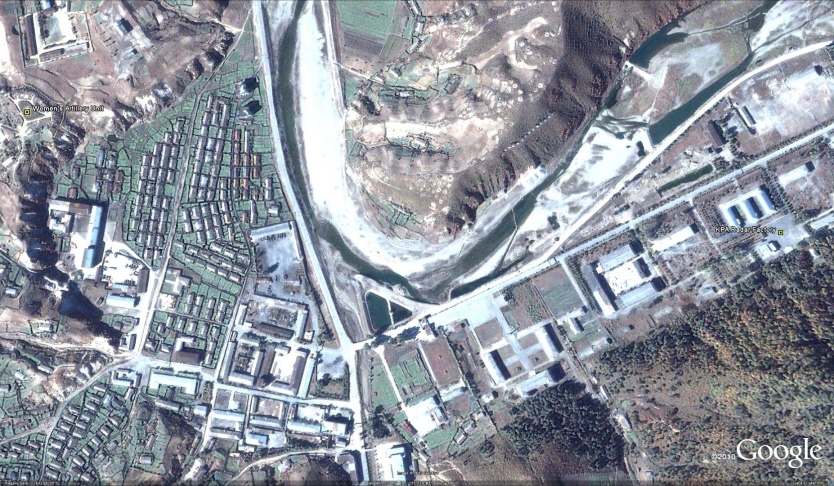
Here is a separate area in northern Dandong where Yalu River high-rise development is underway:


And here is another island in the Yalu River:


Dandong has been the focus of increasing media attention over the last 10 years because it has economically benefitted from increased trade (and expected future trade) between the PRC and DPRK.  

Today it is probably the easiest place to collect “survey data” on the DPRK’s business environment. According to a recent article in the Associated Press (via San Francisco Examiner), the DPRK still has a long way to go before foreign investors will see a climate ripe for investment:

Just across the Yalu River from North Korea, this sleepy border town in China’s Rust Belt is booming.

Towering apartment blocks are going up on the city’s western edge near the new Friendship Road Bridge, which will soon be the second bridge connecting Dandong to the North Korean city of Sinuiju.

Offices for trade and export-import companies dot the main road along the riverfront. A new airport is being built. Shops sell North Korean liquor, blueberry wine, ginseng, stamps and music CDs. And North Korean restaurants offer popular Korean dishes such as stewed dog leg and spicy deep-fried dog.

Dandong – like other parts of northeastern China along the 870-mile border – aims to profit from China and North Korea’s growing cross-border trade, now close to $3 billion a year. At a time when the United States and its allies are looking to isolate the Pyongyang regime for its nuclear program and erratic behavior, including this week’s artillery attack on a South Korean island, this hardscrabble part of China is finding that being North Korea’s back door to the world can be a lucrative business.

China already provides an estimated 90 percent of North Korea’s energy needs and most of its food and weapons. And the most recent gauge of trade between the two countries, from 2008, showed an increase of more than 40 percent from the previous year, according to the Council on Foreign Relations.

But even as officials map out grand plans for more cooperation, merchants and small-scale traders say doing business with North Korea remains problematic at best.

The government is unpredictable, they say, and rules change without warning. They tell horror stories about Chinese traders who have lost millions of dollars in goods or equipment that is expropriated or stolen outright. Many now insist on cash-up-front transactions and mostly conduct business on the Chinese side of the border, where they say they have more protections.

Moreover, while North Korean leaders have visited this part of China and professed admiration for China’s economic boom, local Chinese traders and businessmen in close contact with North Koreans say they don’t expect the country to shift to a market economy anytime soon.

“I haven’t seen any sign the North Korean government wants to open up,” said Cui Weitao, 47, who has been trading fruit, clothing, plastic bowls and chopsticks to North Korea for the past decade. “If they really wanted, they could learn from China and Russia. If they wanted, they could let people go back and forth and trade freely. . . . If they opened the border, their whole country would benefit.”

His friend, Wang Tiansheng, 47, another small-scale trader, agreed. “The thought of economic reform has been there for years but never happens. Not while the father is alive,” he said, referring to the country’s leader, Kim Jong Il. “Maybe when the son takes office.”

China and North Korea have been close allies since Chinese troops crossed the Yalu River to help North Korea fight American and South Korean troops during the Korean War, which is referred to here as the “War to Resist U.S. Aggression and Aid Korea.”

Yet Chinese leaders themselves consider North Korea’s leader an often-troublesome ally because of his brinkmanship with the United States over his country’s nuclear capability and incidents such as this week’s artillery barrage of Yeonpyeong Island, which killed two South Korean marines and two civilians, and the sinking of a South Korean warship in March.

Chinese leaders are reported to be concerned about North Korea’s economic crisis, and they encouraged Kim to embrace market-based economic reforms when he visited China in May and August this year and met with Chinese President Hu Jintao, according to some Hong Kong and South Korean media reports of the visits.

In a bow to reforms, North Korea sent a dozen mayors and provincial chiefs to northeastern China in October to visit factories and chemical plants. Earlier this month, North Korean Premier Choe Yong Rim visited Harbin, in Heilongjiang province, to discuss joint economic projects.

North Korea agreed to lease two Yalu River islands to China to develop into “free trade zones.” Chinese high-tech companies were encouraged to signed agreements to hire North Korean computer experts. In September, after Kim’s second visit, China established a new 100,000-square-foot marketplace in Tumen – across from Namyang in North Korea – for North Koreans to come on one-day passes to sell or trade their goods.

But the Tumen market in many ways illustrates the difficulties of coaxing North Korea to open up. The vast market is now mostly empty because the North Korean government changed its mind about allowing its citizens to come to China to trade freely, Tumen residents said.

One of the few Chinese vendors in the market during a recent visit, who was selling North Korean crab, shrimp and frozen fish, said he lost a lot of money because his North Korean supplier increased prices without warning.

“It’s been really hard and risky to do business with North Korea, firstly because of the complicated procedures of going there,” the seafood vendor said, speaking on the condition of anonymity. He said Chinese traders need an invitation from a state-owned company and three stamps from three departments.

Once inside North Korea, he said, officials “are very greedy. They asked us for digital cameras or DVD players or even computers. We have to buy them dinner, and booze is a must for every time we meet.”

Even the new Friendship Road Bridge being constructed – to augment the existing single-lane bridge – has been difficult to negotiate. China agreed to foot the bill for building the bridge, more than $200 million. But then North Korea demanded China also build a five-star hotel and other infrastructure on the North Korean side, local businessmen said.

Economists said the experience of the local traders confirms their own research: that while North Korean officials publicly claim to want to pursue economic reform, and may speak of emulating China’s success, North Korea’s ruling elite remains deeply ambivalent about anything that might dilute its grip.

“The state has never been comfortable with the market,” said Marcus Noland, senior researcher with the Peterson Institute for International Economics in Washington, who surveyed 300 Chinese companies operating in North Korea. “They see the market potentially as an alternative path to wealth and prestige, and perhaps political power.”

While trying to “deepen their economic integration with China” at the official level, Noland said, North Korean leaders at the same time take steps “to eradicate this kind of normal trading activity at the border” by denying visas and constantly changing the regulations.

“The Chinese do not trust the North Koreans at all,” Noland said.

According to a recent story in the Wall Street Journal, the second DPRK-PRC bridge in Dandong is still tentative:

Construction of the new bridge was originally slated to start in August. Zhao Liansheng, Dandong’s mayor, said in March that building would start in October, and be finished within three years.

“The new bridge is still waiting for the approval of central government,” said an official from the Dandong Transportation Department. “As far as I know, this project is not definite yet.”

I am not sure of the exact location of the new bridge.  If any readers are aware, please let me know.

Read the full stories here:
In Chinese Border Town, Trade With North Korea Can Be Lucrative but Problematic (Dandong, China).
Associated Press (via San Francisco Examiner)
Keith B. Richburg
11/26/2010

Border Bridge Reflects Dilemma
Wall Street Journal
Jeremy Page
11/28/2010

Share

The DPRK’s Damn Dams

Monday, November 15th, 2010

Kumya Dam
A dam is being constructed in Kumya County, South Hamgyong Province, to provide electrical power. Kim Jong-il last visited in August 4, 2010. It is just one of several dams under currently under construction in the DPRK.

Here is a satellite image of the Kumya dam’s construction (Google Earth: 11/25/2008,  39.574232°, 127.104736°)

This new reservoir will flood the locations of three villages (리): Ryongnam-ri (룡남리), Ryongsang-ri (룡상리), and Ryongchon-ri (룡천리).

Estimates of the reservoir size are made by me, but it is fairly obvious where the North Korean engineers expect the reservoir to flood because they have already relocated the villages from their former locations in the flood zone.

Here are the former locations of Ryongchon-ri, Ryongsong-ri, and Ryongnam-ri:

All of the homes, buildings, and factories have been moved (lock, stock, and barrel) to another location. I am not sure where.

Imnam Reservoir
The dislocation caused by the Kumya Dam, however, pails in comparison to the dislocation caused by the creation of the Imnam Reservoir (임남저수지) in Changdo County (창도군).

The Imnam Reservoir bisected the county and flooded nearly half of it, including its capital city and at least 14 villages (리): Jisok-ri (지석리), Pankyo-ri (판교리), Sinsong-ri (신성리), Songdo-ri (성도리), Kisong-ri (기성리), Tangsan-ri (당산리), Tohwa-ri (도화리), Tumok-ri (두목리), Myongchon-ri (면천리), Imnam-ri (임남리), Taejong-ri (대정리), Jon-ri (전리), Onpae-ri (언패리), and Cholpaek-ri (철벽리).

Below is a picture of the Imnam Reservoir along with locations of the various population centers that were flooded.

It appears that the North Koreans constructed a new county capital north of the reservior at 38.652243°, 127.711817° (although this city is not on any maps of North Korea that I have seen). This new city, however, has itself seen severe flood damage (caused by excessive rainfall).  Some of this devastation can bee seen on Google Earth, but the full extent of it is not available with current imagery.

The poor people of Changdo county can’t seem to catch a break.

Lake Paekma
Lake Paekma lies at the head of the Paekma-Cholsan Waterway in Phihyon County ( 40.082356°, 124.695685°).  Two villages were lost to the construction of this reservoir: Sangko-ri(상고리) and Ryongun-ri(룡운리).  In the images below you can see the locations of the remnants of these villages as well as their disappearance under the waters.

Military losses to dam construction
Civilians are not the only ones to have suffered dislocation at the hands of the DPRK’s energy policy. The airforce lost a couple of facilities as well.

Thaechon County:
The North Korean air force lost one training facility to a  new dam on the Taeryong River (대령강) in Thaechon County ( 39.865138°, 125.562139°).  Here and here are the before and after pictures.

Tongrim County:
And most recently, the an airfield and heliport in Tongrim County ( 39.918570°, 124.840542°) appears to be in danger of flooding as a result of the rising Maepong Reservoir (매봉저수지)–a lake on which “someone” has a very nice house:

Share

Jo Myong-rok’s farewell ride

Thursday, November 11th, 2010

UPDATE: Using North Korean television footage, I mapped out Jo Myong-rok’s funeral procession route on Google Earth.

The procession began at the Central Worker’s Hall (home of the General Federation of Trade Unions of Korea) where the VMAR’s wake was held:

The procession then traveled west to the Potong Gate (near Sojang Hall where state funerals are normally held) and then north to the Patriotic Martyr’s Cemetary. 

Jo Myong-rok was bruied in the front row of the cemetary in one of the empty spots.

I wonder which two individuals will be buried next to him?  Judging from the satellite imagery, it appers this cemetary is being expanded for additional martyrs.  I wonder what the criteria are to be buried here.  

Here is the story in KCNA.

ORIGINAL POST: According to KCNA (11/6/2010):

Vice Marshal of the Korean People’s Army Jo Myong Rok, member of the Presidium of the Political Bureau of the Central Committee of the Workers’ Party of Korea, first vice-chairman of the DPRK National Defence Commission and deputy to the Supreme People’s Assembly, died of an inveterate heart disease at 10:30 a.m. on Nov. 6, Juche 99 (2010) at the age of 82 to our sorrow.

Born into a poor peasant’s family in Yonsa County, North Hamgyong Province on July 12, Juche 17 (1928) Jo Myong Rok was a revolutionary comrade loyal to General Secretary Kim Jong Il and a prominent activist of the WPK, the state and the army of the DPRK who devoted his whole life to the sacred struggle for the freedom and independence of the country and the victory of the cause of socialism.

He grew up to be an able military and political official under the care of the party and the leader after the country’s liberation.

He worked for years at important posts of the party, the state and the army.

In the period of the hard-fought Fatherland Liberation War against the U.S. imperialists’ armed invasion he bravely fought as a pilot of the KPA for the victory in the war. He worked hard for the development of the air force, holding posts of squadron commander, group commander and divisional commander of an air unit and the chief of the staff and commander of the air force of the KPA in the post-war period.

Holding important posts as the director of the General Political Bureau of the KPA from October, Juche 84 (1995) and first vice- chairman of the DPRK National Defence Commission from September, Juche 87 (1998), he energetically worked to thoroughly implement the Juche-oriented military line of the WPK and firmly guarantee the building of a thriving nation and the victory of the revolutionary cause of Juche with matchless military power.

He was elected alternate member of the C.C., the WPK in November, Juche 64 (1975), member of the C.C., the WPK and member of the Central Military Commission of the WPK in October, Juche 69 (1980) and member of the Presidium of the Political Bureau of the C.C., the WPK in September, Juche 99 (2010) and worked as a deputy to the Supreme People’s Assembly from the sixth Supreme People’s Assembly held in November, Juche 66 (1977).

He was awarded Order of Kim Il Sung, the highest order of the DPRK, the titles of Hero of the DPRK and Labour Hero and many other orders and medals including Order of National Flag First Class and Order of Freedom and Independence First Class for the distinguished feats he performed for the party and the revolution, the country and its people.

He received the title of vice marshal of the KPA in October, Juche 84 (1995).

An obituary of Jo Myong Rok was jointly issued by the C.C., the WPK, the Central Military Commission of the WPK, the DPRK National Defence Commission and the Presidium of the DPRK Supreme People’s Assembly on Saturday.

The obituary said that his death is a great loss to the party, the army and people of the DPRK waging a dynamic struggle to win the victory of the cause of building a thriving socialist nation and bring earlier the independent reunification of the country. Though he passed away, the exploits he performed for the party and the revolution, the country and its people will shine long along with the victorious advance of the revolutionary cause of Juche, it stressed.

On the same day, the C.C., the WPK, the Central Military Commission of the WPK, the DPRK National Defence Commission and the Presidium of the DPRK Supreme People’s Assembly announced that the late Jo Myong Rok would be accorded a state funeral and formed a state funeral committee with Kim Jong Il as its chairman and Kim Jong Un and 169 others as its members.

The state funeral committee informed the public that the bier of the deceased would be placed in the Central Hall of Workers, it would receive mourners from 10:00 on Nov. 8 to 18:00 on Nov. 9 and the hearse would leave the hall at 9 a.m. on Nov. 10.

KCNA also reports (11/8/2010):

Leading officials of the state and armed forces organs Monday visited the bier of Vice Marshal of the Korean People’s Army Jo Myong Rok, member of the Presidium of the Political Bureau of the Central Committee of the Workers’ Party of Korea, first vice-chairman of the National Defense Commission of the DPRK and deputy to the Supreme People’s Assembly, to express deep condolences over his death.

Seen standing before the bier of the late Jo Myong Rok was a wreath sent by Kim Jong Il, general secretary of the Workers’ Party of Korea, chairman of the DPRK National Defence Commission and supreme commander of the Korean People’s Army.

Also seen standing before the bier were wreaths sent by the C.C., the WPK, the Central Military Commission of the WPK, the NDC of the DPRK, the Presidium of the Supreme People’s Assembly of the DPRK, the DPRK Cabinet and the Ministry of the People’s Armed Forces.

Among the mourners were Choe Yong Rim, Jon Pyong Ho, Pyon Yong Rip, Kim Rak Hui, Kim Chang Sop, Ri Ha Il, anti-Japanese veteran fighters Ri Ul Sol and Kim Chol Man, and Kim Yong Dae, chairman of the C.C., the Korean Social Democratic Party, and Ryu Mi Yong, chairperson of the C.C., the Chondoist Chongu Party.

They observed a moment’s silence in memory of the late Jo Myong Rok and expressed deep condolences to the bereaved families of the deceased.

On the same day officials of armed forces organs including the NDC and the Ministry of the People’s Armed Forces, servicepersons of KPA and the Korean People’s Internal Security Forces, officials of the party and power organs, working people’s organizations, ministries and national institutions, working people from all walks of life, the diplomatic corps and the military attaches corps here and overseas Koreans visited the Central Hall of Workers where the bier of the deceased was placed and expressed condolences over his death.

Additional Information:
1. Michael Madden has additional information on the VMAR here and here.

2. The media is highlighting that Kim Jong-un has been named after his father as a member of the state funeral committee.  See here and here.

3. To see a satellite image of the Central Worker’s Hall click here.  This will be the first funeral to be held in this facility since at least 1996.  As far as I can tell this is the first funeral to be held there.

4. Most other state funerals are conducted in Sojang Hall in Potonggang District (Satellite image here).  See a previous post I wrote about the geography of DPRK state funerals here.

Share

Rimjingang, Imjingang, and the Sunchon Vinalon Complex

Monday, November 8th, 2010

Writing in the Wall Street Journal, Evan Ramstad notes the following information about Rimjingang and Imjingang:

Japanese publisher Jiro Ishimaru has gotten a lot of attention over the past month for his new English-language book of articles from Rimjingang – the magazine about North Korea that’s written by North Koreans.

Over the past six years, he’s worked closely with a few dozen North Koreans to get insiders’ stories published.

Less well known is the North Korean defector in Seoul, Choi Jin-i, who worked closely with him until recently. She published a Korean version of the magazine while he handled Japanese.

They split earlier this year over funding differences. Mr. Ishimaru’s magazine is commercially-funded while Ms. Choi’s is supported by charitable contributions. Ms. Choi’s magazine now has a slightly different name. It’s called Imjingang.

Their writers are mainly North Koreans with the political and financial ability to visit China, where they can communicate freely.

For both Ms. Choi and Mr. Ishimaru, the biggest challenge is getting contributors to verify the information they report.

Mr. Ishimaru’s favorite scoop came last year. It was a video report that showed a 20-year-old textile factory in the North Korean city of Suncheon, long touted as a showplace industrial plant by North Korea’s state media, is actually unused and crumbling.

“The factory might have only run on opening day when the Great Leader (Kim Jong Il’s father Kim Il Sung) was there,” Mr. Ishimaru says. “There had been rumors inside the country that the factory never ran, but nobody outside the nation confirmed that. Our reporter went there and for the first time filmed the factory in ruins.”

Ms. Choi says her favorite article appeared in the magazine’s first issue in 2007. It was an analysis of North Korea’s economic situation by a high-ranking government official. She said she worked for more than a year to persuade the official to give an interview.

The quality of information in that interview surprised North Korea watchers. “Many South Korean scholars said they didn’t know there was an intellectual in North Korea,” Ms. Choi said.

And the surprise for me: The factory in Sunchon mentioned in the story is the Sunchon Vinalon Complex (not to be confused with the 2.8 Vinalon Complex in Hungnam).  I actually used the video mentioned in this story and matched it up with Google Earth Satellite imagery to confirm it was shot in the DPRK.  You can see the blog post and video here.

Read the Wall Street Journal article here:
North Korea by North Koreans; How the Magazines Work
Wall Street Journal
Evan Ramstad
11/8/2010

Share

Wonsan leadership compound upgraded

Wednesday, November 3rd, 2010

Several days ago, the Daily NK reported on the reconstruction of a few elite compounds in the DPRK.  See the previous post here.  Satellite imagery on Google Earth also reveals that a compound in Wonsan has been refurbished.

Wonsan compound 2002
(click image to enlarge)

Wonsan compounf 2009
(click image to enlarge)

Although the satellite imagery for 2009 is not particularly clear, it is easy to observe that the main complex, in the center of the screen, has been rebuilt and modernized.  There is no more lake.  It also appears that several beach guest houses or cabanas have been built on the eastern shore.

Given the sum of my knowledge about this particular location (which is minimal), I believe this compound is intended for use by KPA officials.  This is because it is located across the Wonsan Bay from a much larger elite complex for members of the Worker’s Party. See the map below:

Additionally, this site has been the location of two high-profile artillery tests by KPA units 681 and 851. See here and here.

If you are aware of any publications which discuss this compound, please let me know.

Share

China to lease two DPRK islands (update)

Thursday, October 28th, 2010

(via One Free Korea) Global Times reports (in Korean) that the DPRK is leasing two islands (황금평 and 위화도) to China.

Here is a satellite image of the two islands (highlighted):

According to the article:

South Korea’s Hankook Ilbo daily newspaper reported Thursday that North Korea has decided to extend the lease terms of two islands to Chinese companies for the establishment of a free trade zone.

However, analysts say the zone will more likely be developed as a trade area to facilitate business with China.

Both islands are located on the Yalu River, which constitutes the northwestern boundary between North Korea and the northeast region of China.

Hankook Ilbo reported that North Korean leader Kim Jong-il agreed to establish a free trade zone of 50 square kilometers on the two islands during his visit to China in May, and foreigners won’t need a visa to visit the islands.

The extension of the lease term by 100 years – starting this past May – to Chinese companies is unusual because Pyongyang generally leases land to foreign companies for 50 years, the report said.

By press time, state-run media in North Korea hadn’t confirmed the report.

South Korea’s Yonhap News Agency reported earlier this year that in order to attract foreign investment to North Korea, Pyongyang will set up a free trade area, located near the Sino-North Korean border city of Dandong, Liaoning Province, to be developed by a Chi-nese enterprise.

The report quoted an informed source as saying the scale of investment in the two islands will total $800 million.

“I don’t think North Korea will establish a free trade zone in the border areas that soon,” said Lü Chao, director of the Korean Research Center at China’s Liaoning Academy of Social Sciences. “But it is likely that the two islands will be developed into a border trade zone that can help improve the lives of the locals and be conducive to regional stability.”

Lü told the Global Times that developing a free trade zone in North Korea’s border areas with China might take longer.

Separately, Japan’s Yomiuri Shimbun newspaper reported Monday that Kim Jong-un, the third son of Kim Jong-il, recently said his country needs food more than bullets.

“In the past, it was all right to have bullets and no food, but now we must have food, even though we don’t have bullets,” the newspaper quoted him as saying.

The paper said Kim Jong-un made the remarks during a visit to Kimchaek city in Ham-gyong Province in late September, and the comments are confirmed in documents recently disseminated to party officials.

Kim Jong-un was promoted to a four-star general and vice chairman of the ruling Workers’ Party’s Central Military Commission last month during an important meeting of the party.

The White House said Thursday that North Korea appeared to be in the early stages of a leadership transition, and it would still take some time to discern the final outcome.

“We’re watching the transition closely,” Jeff Bader, US President Barack Obama’s Asia adviser, told reporters.

The idea of building a special economic zone near Sinuiju has been proposed several times but it never seems to take hold.  Given the level of economic growth in Dandong over the last five years, and China’s growing clout in the DPRK, maybe things will be different this time.

Read the full aticle here:
NK leases islands to Beijing: report
Global Times
Wang Zhaokun
10/29/2010

Share