Archive for the ‘Rason Economic and Trade Zone (Rajin-Sonbong)’ Category
Thursday, June 19th, 2008
After China and the USA made high-profile food donations to North Korea, the Russians finally joined the game. Russia’s Foreign Minister claims that by the end of June his country will have sent 3,000 tons of flour to UN World Food Program distributors in North Korea. The first aid deliveries arrived in North Korea by train on June 11.
I am surprised Russia waited so long to get into the game. Russia has been prodding North Korea to link its Trans-Siberian rail traffic to South Korea, and they want to make sure the Chinese don’t squeeze them out of North Korea’s Raijin Port (which does not freeze in the winter). Food aid might not have helped these processes along, but waiting so long to jump on the bandwagon can’t have helped.
In March of this year, the Russians inked a deal to renovate the railway lines between their border and Raijin (the tracks are different gagues).
Read about the aid here:
Russia to deliver 3,000 tons of flour to North Korea
Novosti
6/9/2008
Russia sends food aid to North Korea
Associated Press
6/19/2008
Posted in Foreign aid statistics, Political economy, Railways, Rason Economic and Trade Zone (Rajin-Sonbong), Russia | 1 Comment »
Tuesday, March 4th, 2008
Writing in today’s Asia Times, Dr. Leonid Petrov analyses the complexity of Russia, Rok, DPRK, and Chinese relations:
Russia and North Korea:
Territorial claims, in one form or another, involve almost all countries adjacent in this region with the exception of Russia and Korea. The Joint Russian Federation-DPRK Commission for the Demarcation of State Borders has recently completed its work by documenting and marking the 17-kilometer frontier. This strip of uninhabited and swampy land in the mouth of the Tumannaya (Tuman-gang) River plays an exceptionally important geopolitical role. It not only provides the two countries with land access to each other, but also prevents Chinese access to the East Sea (Sea of Japan).
China and North Korea:
Here, some 50km north of the small port that forms the core of North’s Rajin-Seonbong Special Economic Zone, the interests of Russia and China are now at stake. Russia is rapidly repairing the railroad track, and China (in a similarly speedy manner) is constructing a new automobile highway, both leading from their respective borders to the port of Rajin. Russia, investing at least 1.75 billion rubles (US$72 million) into this project, seeks to strongly connect Rajin (and the rest of northern Korea) to its Trans-Siberian Railroad. China, in turn, hopes to divert the growing cargo traffic to its own territory, offering the efficient network of railroads for delivery of South Korean and Japanese goods to Central Asian and European markets. What position will the government of North Korea take in this clash of ambitions?
Russia and South Korea (energy and trade):
In 2007, the volume of the export of “black gold” from Russia to South Korea reached 38.13 million barrels (2.7 times more than in the previous year). The relative proximity of the Russian oil and gas fields is an attractive factor for Korean companies who actively search for alternatives to Middle East oil suppliers. This year South Korea will for the first time start importing natural gas from Russia. The expected volume of delivery during 2008 is 1.5 million tons (or 5.1% of South Korea’s annual demand).
and
Trade relations between Russia and Korea are steadily growing. According to customs statistics, last year Russia recorded the sharpest increase of South Korean imports (56.2% more than in 2006). Due to the inflow of “petro-dollars” the new class of nouveaux riches in Russia began actively buying Korean automobiles, cell phones, television sets and LCD monitors. South Korea exported to Russia goods worth US$8.1 billion (including $3.296 billion of automobiles, $859 million of mobile phone equipment, motor vehicles and spare parts worth $659 million). As for trade with North Korea, in 2006 Russia occupied third place after China and South Korea and absorbed 9% of the total $3.18 billion spent by the North on imports.
More on Russia/South Korea energy talk here.
The whole article deserves reading here:
Russia lays new tracks in Korean ties
Asia Times
Leonid Petrov
3/5/2008
Posted in Automobiles, China, Electricity, Energy, Foreign direct investment, International trade, Natural Gas, Oil, Railways, Rason Economic and Trade Zone (Rajin-Sonbong), Russia, Sea shipping, Trade Statistics, Transportation | 6 Comments »
Tuesday, February 12th, 2008
Kang: North Korean Trade Potential
Council on Foreign Relations
12/17/2007
Last December, David C. Kang, a professor of government at Dartmouth College and an adjunct professor at Tuck Business School, discussed the North Korean economy for the Council on Foreign Relations. I have excerpted some of his comments below.
His view on the new North-South cargo train service:
It doesn’t have huge economic significance in the overall GDP of North Korea. But it does have major economic significance in the fact that what North Korea had to do in order to let a train go through was an awful lot of adjustment[…]in terms of linking up the railroad, all the ministries had to prepare. The old [Korean Energy Development Organization] had this problem as well. [W]hen they wanted Americans and South Koreans working in North Korea to build this light-water reactor, [they] had to set up protocols [Post offices, phone calls, where they were going to stay, etc]. It is pretty significant in terms of how much they had to adjust.
He quoted the following figures on North – South trade:
From $200 million in 1998, to now exceeding $1.7 billion in 2007. South Korea’s total trade volume is $250 billion.
His opinion on the direction of the North Korean economy:
At this point what we’re seeing is very initial steps on the part of North Korea as they try to open up reform and yet maintain control. At the same time, they are being forced into a number of institutional changes and mind-set changes that are the first step forward in this process.
His view of North Korea’s comparative advantage:
Most of the companies that have gone in—the South Korean companies that have gone in—are assembly and light manufactures, such as or textiles and light consumer goods. This is the sort of obvious point of departure. It’s not hugely capital intensive in terms of building factories, and can take advantage of North Korean cheap labor and South Korean technological advantages.
There are a lot of potential mineral resources in North Korea, which would require a whole infrastructure of legal reforms to happen before anyone would take care of them. But at this point the safest bets are the ones that are on the order of assembly and light manufactures in the North and then exporting them out.
His view of South Korea’s long term goals:
If there’s unification, or even better relations, and South Korean companies can use cheap North Korean labor, instead of having to send those factories to China or Vietnam—not only do they speak Korean, they’re culturally similar, and the labor would be cheaper.
[I]f you could reconnect the railroads, from Japan, through Pusan [South Korea], up through North Korea, then out to China and Russia, you would be linking up all these economies in a much more efficient way than they are now. So everybody wants that. But obviously there’s the political problem. And even on the infrastructure side, the North Korean rail system is so old and so decrepit, that basically it would have to be rebuilt from zero. But the potential upsides are massive, in the long run.
His view of China’s engagement:
China has been essentially as deeply involved in economic engagement with North Korea as has South Korea—and by some measures, actually more so. Whereas South Koreans just do this assembling, some Chinese companies are moving in and building full factories in the North. There’s a lot of interest in Chinese-North Korean economic relations on both sides.
Posted in China, Economic reform, Foreign direct investment, International trade, Kaesong Industrial Complex (KIC), Manufacturing, Mining/Minerals, Mt. Kumgang Tourist Special Zone, Political economy, Price liberalization, Railways, Rason Economic and Trade Zone (Rajin-Sonbong), Sea shipping, South Korea, Special Economic Zones (Established before 2013), Statistics, Trade Statistics, Transportation | Comments Closed
Wednesday, February 6th, 2008
Yesterday the Jong Ang Daily reported that Hyundai Asan hopes to draw more tourists to the DPRK this fall, but their forecasting record is not exactly stellar:
The number of tourists to Mount Kumgang tallied 350,000 last year. The North Korean tour unit of Hyundai Asan hopes to pull the number of visitors up to 430,000 this year, 10,000 of whom would head to Kaesong, which began tours in December, and 15,000 of whom would visit Mount Paektu, with tours slated to start in May.
Hyundai Asan had marked annual losses from 1999 until it made profits in 2005. Its 2007 profits totaled 10 billion won.
Today, Andrei Lankov, writing in the Asia Times, chimes in on his experiences with the new Kaesong Tour and gives a rationale for western participation in such activities:
The Kaesong tour is the first project which gives the average South Korean, Mr Kim or Ms Pak, an opportunity to see a semblance of North Korean life. Hitherto, only a handful of South Koreans, most of them government officials, have been able to visit North Korean cities. Now, for the first time in 60-odd years, a very limited opportunity is open for an anybody who is willing to pay a fee.
Of course, North Korean authorities went to extraordinary lengths to prevent any interaction between locals and visitors. The list of prohibited items is quite impressive. Tourists cannot take any kind of printed material, computers and computer equipment, mobile phones, radios and video cameras, universal serial bus and other memory devices. The old film cameras are banned as well. Only digital cameras are allowed into the North, since at the border check point North Korean police officials check every single picture taken by every single tourist.
Despit the limitations, Lankov still feels that these types of exchanges are ultimately worthwhile…
The extraordinary security measures undertaken by the North Korean authorities ensure that only a very limited number of northerners are allowed to approach the visitors. Nonetheless, the tours are a major event.
Every single day, a small city is invaded by an impressive motorcade: 10 large imposing buses, half a dozen jeeps and other vehicles – incidentally, produced in South Korea. The preparations are thorough and, one might suspect, seriously disrupt the city’s routine. The North Koreans can see, albeit from the distance, the visitors – their dress, their height, their behavior. The South Koreans can immediately see how poor the North is. It seems that North Koreans, being necessarily street-smart, also instantly feel the South Korean prosperity.
The waitresses, girls in small stalls and even a handful of genuine guides (not the plaincloth intelligence operatives) who can see the visitors will also notice a lot. Even the willingness of the guests to spend a dollar on a cup of instant coffee or a few cookies is an important sign to them – after all, the average monthly salary in Kaesong is about $4. Those South Korean guests definitely do not look like impoverished victims of evil US imperialism. For a while it will be possible to explain away their extravagant behavior by insisting that those people come from the exploitive elite. But the longer the tours continue, the more difficult the task will become.
So why did the North decide to open Kaesong in the first place? It seems that the major reason is the easy currency income the project brings to Pyongyang. Every visitor pays 180,000 won ($190) – a hefty sum for a one-day bus trip. Out of this amount, 100,000 won goes to the North Korean authorities. All investment into necessary infrastructure is done by Hyundai Asan, so for the North this is easy money. Since 17,000 visitors joined the tours during the first two months of its operations, annual earnings could be in excess of $10 million.
At the same time, they might believe that the Kaesong area has become ideologically contaminated anyway. The Kaesong industrial park is located just a few kilometers from the city. In this facility, some 15,000 North Korean workers are employed in factories owned and run by South Korean capital, largely small businesses which are in desperate need of “cheap labor”.
These workers interact with South Koreans regularly, and they also see life inside the industrial park, which presents a remarkable contrast with their native towns or villages: well-paved roads, trees planted everywhere, modern buildings and round-the-clock supply of water and electricity. Even traffic lights, famously absent from North Korea, are present in this de-facto South Korean enclave.
So why did the North decide to open Kaesong in the first place? It seems that the major reason is the easy currency income the project brings to Pyongyang. Every visitor pays 180,000 won ($190) – a hefty sum for a one-day bus trip. Out of this amount, 100,000 won goes to the North Korean authorities. All investment into necessary infrastructure is done by Hyundai Asan, so for the North this is easy money. Since 17,000 visitors joined the tours during the first two months of its operations, annual earnings could be in excess of $10 million.
The only way to promote change, evolutionary or revolutionary, is to bring North Koreans into contact with the outside world. The North Korean dictator and his elite might see partial exchanges as an easy way to earn money, which is necessary for them to maintain their caviar and cognac lifestyle. In the short term they are probably right. But in the long term, the exchanges will make breaches in the once monolith wall of information blockade. Sooner or later, those breaches will become decisive.
The full articles can be found here:
Tourism boost to North in works
Joong ang Daily
Moon So-young
2/6/2008
A breach in North Korea’s iron curtain
Asia Times
Andrei Lankov
2/7/2008
Posted in Economic reform, Foreign direct investment, Kaesong Industrial Complex (KIC), Mt. Kumgang Tourist Special Zone, Rason Economic and Trade Zone (Rajin-Sonbong), South Korea, Special Economic Zones (Established before 2013), Tourism | 1 Comment »
Friday, December 14th, 2007
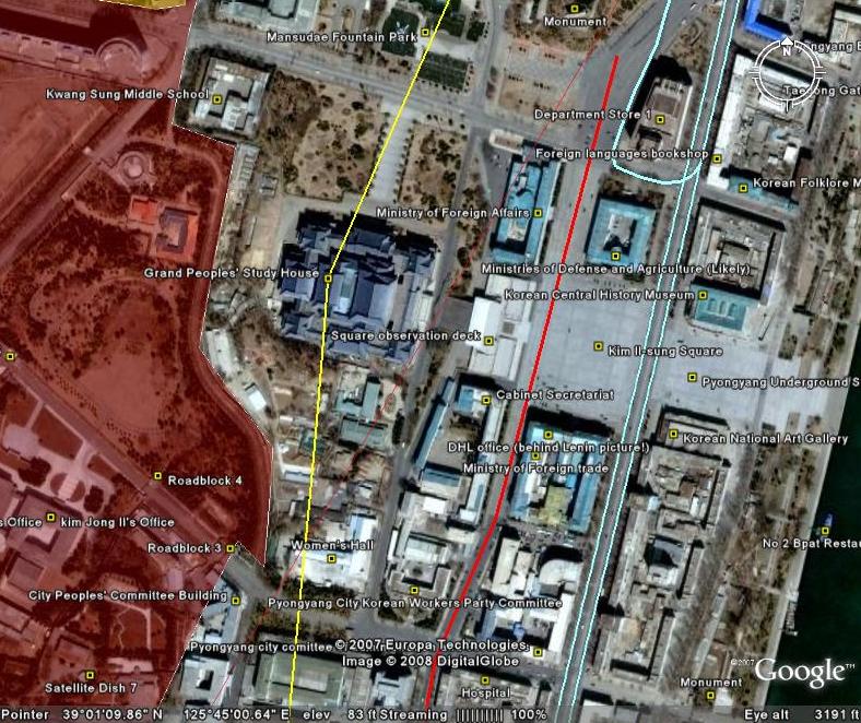
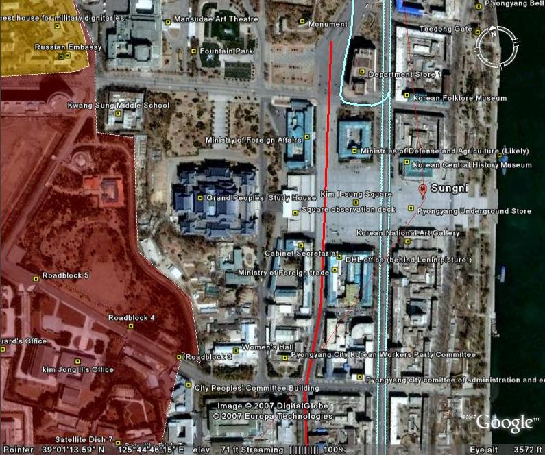
The most authoritative map of North Korea on Google Earth
North Korea Uncovered v.7
Download it here
 This map covers North Korea’s agriculture, aviation, cultural locations, manufacturing facilities, railroad, energy infrastructure, politics, sports venues, military establishments, religious facilities, leisure destinations, and national parks. It is continually expanding and undergoing revisions. This is the sixth version.
Additions to the latest version of “North Korea Uncovered” include: A Korean War folder featuring overlays of US attacks on the Sui Ho Dam, Yalu Bridge, and Nakwon Munitians Plant (before/after), plus other locations such as the Hoeryong Revolutionary Site, Ponghwa Revolutionary Site, Taechon reactor (overlay), Pyongyang Railway Museum, Kwangmyong Salt Works, Woljong Temple, Sansong Revolutionary Site, Jongbansan Fort and park, Jangsan Cape, Yongbyon House of Culture, Chongsokjong, Lake Yonpung, Nortern Limit Line (NLL), Sinuiju Old Fort Walls, Pyongyang open air market, and confirmed Pyongyang Intranet nodes.
Disclaimer: I cannot vouch for the authenticity of many locations since I have not seen or been to them, but great efforts have been made to check for authenticity. These efforts include pouring over books, maps, conducting interviews, and keeping up with other peoples’ discoveries. In many cases, I have posted sources, though not for all. This is a thorough compilation of lots of material, but I will leave it up to the reader to make up their own minds as to what they see. I cannot catch everything and I welcome contributions.
Posted in Architecture, Art, Automobiles, Aviation, Cell phones, Civil society, Coal, Committee for Cultural Relations with Foreign Countries, Communications, Computing/IT, Construction, Dams/hydro, Department Store No. 1, Education, Electricity, Email, Energy, Film, Finance, Football (soccer), Forestry, Gambling, General markets (FMR: Farmers Market), Golf, Google Earth, Hana Electronics Company, Health care, Hoteling, Hwanggumphyong and Wihwado Economic Zones (Sinuiju), Hyesan Youth Cooper Mine, International Aid, Internet, Intranet, Juche, Kaesong Industrial Complex (KIC), Kim Chaek University of Technology, Kim Il Sung University, Korea Computer Center (KCC), Korean Buddhist Association, Korean People's Army, Light Industry, Lumber, Mansudae creative Company (art studio), Manufacturing, Mass games, Maternity Hospital, Military, Mining/Minerals, Ministry of foreign Affairs, Ministry of Foreign Trade, Mt. Kumgang Tourist Special Zone, Musan Mine, Nuclear, Pyongyang Embroidery Institute, Pyongyang Film Studio, Pyongyang Informatics Center (PIC), Pyongyang International Information Center of New Techn, Pyongyang International Trade Fair, Pyongyang Metro, Pyongyang University of Medicine, Radio, Railways, Rason Economic and Trade Zone (Rajin-Sonbong), Real estate, Religion, Restaurants, Sea shipping, Sports, Television, Transportation, Wind | Comments Closed
Sunday, November 11th, 2007
The most authoritative map of North Korea on Google Earth
North Korea Uncovered: Version 6
Download it here
 This map covers North Korea’s agriculture, aviation, cultural locations, manufacturing facilities, railroad, energy infrastructure, politics, sports venues, military establishments, religious facilities, leisure destinations, and national parks. It is continually expanding and undergoing revisions. This is the sixth version.
Additions to the newest version of North Korea Uncovered include: Alleged Syrian nuclear site (before and after bombing), Majon beach resort, electricity grid expansion, Runga Island in Pyongyang, Mt. Ryongak, Yongbyon historical fort walls, Suyang Fort walls and waterfall in Haeju, Kaechon-Lake Taesong water project, Paekma-Cholsan waterway, Yachts (3), and Hyesan Youth Copper Mine.
Disclaimer: I cannot vouch for the authenticity of many locations since I have not seen or been to them, but great efforts have been made to check for authenticity. These efforts include pouring over books, maps, conducting interviews, and keeping up with other peoples’ discoveries. In many cases, I have posted sources, though not for all. This is a thorough compilation of lots of material, but I will leave it up to the reader to make up their own minds as to what they see. I cannot catch everything and I welcome contributions.
Posted in Advertising, Agriculture, Architecture, Automobiles, Aviation, Banking, Black markets, Committee for Cultural Relations with Foreign Countries, Communications, Computing/IT, Dams/hydro, Department Store No. 1, Economic reform, Education, Electricity, Energy, Environmental protection, Film, Finance, Fiscal & monetary policy, Football (soccer), Forestry, Gambling, Gasoline, General markets (FMR: Farmers Market), Golf, Google Earth, Hana Electronics Company, Health care, Hoteling, Hwanggumphyong and Wihwado Economic Zones (Sinuiju), Hyesan Youth Cooper Mine, Kaesong Industrial Complex (KIC), Kim Il Sung University, Korea Computer Center (KCC), Library, Light Industry, Mansudae creative Company (art studio), Manufacturing, Mass games, Maternity Hospital, Military, Mining/Minerals, Ministry of Culture, Ministry of Foreign Trade, Mt. Kumgang Tourist Special Zone, Musan Mine, Music, Nuclear, Pyongyang Embroidery Institute, Pyongyang Film Studio, Pyongyang Informatics Center (PIC), Pyongyang International Information Center of New Techn, Pyongyang International Trade Fair, Pyongyang Metro, Railways, Rason Economic and Trade Zone (Rajin-Sonbong), Real estate, Religion, Restaurants, Sea shipping, Special Economic Zones (Established before 2013), Sports, Steel, Supreme Peoples Assembly, Television, Tourism, Transportation, Water, Wind | Comments Closed
Saturday, October 6th, 2007
Version 5: Download it here (on Google Earth)
This map covers North Korea’s agriculture, aviation, cultural locations, manufacturing facilities, railroad, energy infrastructure, politics, sports venues, military establishments, religious facilities, leisure destinations, and national parks. It is continually expanding and undergoing revisions. This is the fifth version.
Additions to the latest version of “North Korea Uncovered” include updates to new Google Earth overlays of Sinchon, UNESCO sites, Railroads, canals, and the DMZ, in addition to Kim Jong Suk college of eduation (Hyesan), a huge expansion of the electricity grid (with a little help from Martyn Williams) plus a few more parks, antiaircraft sites, dams, mines, canals, etc.
Disclaimer: I cannot vouch for the authenticity of many locations since I have not seen or been to them, but great efforts have been made to check for authenticity. These efforts include pouring over books, maps, conducting interviews, and keeping up with other peoples’ discoveries. In many cases, I have posted sources, though not for all. This is a thorough compilation of lots of material, but I will leave it up to the reader to make up their own minds as to what they see. I cannot catch everything and I welcome contributions.
I hope this map will increase interest in North Korea. There is still plenty more to learn, and I look forward to receiving your additions to this project.
Posted in 1990s Famine, Advertising, Agriculture, Architecture, Arduous March, Art, Automobiles, Aviation, Banking, Civil society, Coal, Communications, Computing/IT, Cosmetics, Dams/hydro, DPRK organizations, Economic reform, Education, Electricity, Energy, Environmental protection, Film, Finance, Fiscal & monetary policy, Football (soccer), Foreign direct investment, Forestry, Gambling, Gasoline, General markets (FMR: Farmers Market), Golf, Google Earth, Health care, Hoteling, Hwanggumphyong and Wihwado Economic Zones (Sinuiju), Illicit activities, Juche, Kaesong Industrial Complex (KIC), Labor conditions/wages, Leisure, Library, Light Industry, Manufacturing, Mass games, Military, Mining/Minerals, Mt. Kumgang Tourist Special Zone, Music, Nuclear, Political economy, Pyongyang International Trade Fair, Pyongyang Metro, Radio, Railways, Rason Economic and Trade Zone (Rajin-Sonbong), Real estate, Religion, Restaurants, Sea shipping, Special Economic Zones (Established before 2013), Television, Tourism, Transportation, Water, Worker's Party | 2 Comments »
Wednesday, August 29th, 2007
The most authoritative, publicly available map of North Korea
Version 4: August 29, 2007
Download it here
This map covers North Korea’s agriculture, aviation, cultural locations, manufacturing facilities, railroad, energy infrastructure, politics, sports venues, military establishments, religious facilities, leisure destinations, and national parks. It is continually expanding and undergoing revisions. This is the fourth version.
Additions to the latest version of “North Korea Uncovered” include the city of Manpo along the Chinese border, KEDO, Kumgang Resort expansion, Kaesong Industrial Zone, as well as a few more parks, antiaircraft sites, dams, mines, canals, etc. I have also added more links in the menu which will tell the viewer a bit about the locations themselves. I have also changed the color scheme to make the collage easier to view.
Disclaimer: I cannot vouch for the authenticity of many locations since I have not seen or been to them, but great efforts have been made to check for authenticity. These efforts include pouring over books, maps, conducting interviews, and keeping up with other peoples’ discoveries. In many cases, I have posted sources, though not for all. This is a thorough compilation of lots of material, but I will leave it up to the reader to make up their own minds as to what they see. I cannot catch everything and I welcome contributions.
I hope this map will increase interest in North Korea. There is still plenty more to learn, and I look forward to receiving your additions to this project.
Posted in Agriculture, Architecture, Automobiles, Aviation, Biotech, Dams/hydro, Education, Electricity, Energy, Environmental protection, Fiscal & monetary policy, Forestry, Gasoline, General markets (FMR: Farmers Market), Google Earth, Health care, Hoteling, Hwanggumphyong and Wihwado Economic Zones (Sinuiju), International trade, Kaesong Industrial Complex (KIC), Labor conditions/wages, Leisure, Library, Light Industry, Lumber, Manufacturing, Military, Mining/Minerals, Mt. Kumgang Tourist Special Zone, Political economy, Pyongyang International Trade Fair, Pyongyang Metro, Railways, Rason Economic and Trade Zone (Rajin-Sonbong), Real estate, Sea shipping, Special Economic Zones (Established before 2013), Tourism, Transportation, Water, Wind | 1 Comment »
Tuesday, July 31st, 2007
Now available on Google Earth!
(click above to download to your own Google Earth)
North Korea Uncovered v.3
Google Earth added a high-resolution overlay of the area between Pyongyang and Nampo. In it, most of the Koguryo tombs listed with UNESCO are now distinguishable. In addition, viewers can see the latest Kim Jong Il palace (including a yacht), the DPRK’s premier golf course, and the Chinese-built Taean Glass factory. I have also made some progress in mapping out the DPRK electricity grid.
This is the most authoritative map of North Korea that exists publicly today. Agriculture, aviation, cultural institutions, manufacturing, railroad, energy, politics, sports, military, religion, leisure, national parks…they are all here, and will captivate anyone interested in North Korea for hours.
Naturally, I cannot vouch for the authenticity of many locations since I have not seen or been to them, but great efforts have been made to check for authenticity. In many cases, I have posted sources, though not for all. This is a thorough compilation of lots of material, but I will leave it up to the reader to make up their own minds on the more “controversial” locations. In time, I hope to expand this further by adding canal and road networks.
I hope this post will launch a new interest in North Korea. There is still plenty more to learn, and I look forward to hearing about improvements that can be made.
Posted in Architecture, Automobiles, Aviation, Banking, Coal, Communications, Computing/IT, Dams/hydro, Education, Electricity, Energy, Football (soccer), Forestry, Gambling, Gasoline, General markets (FMR: Farmers Market), Golf, Google Earth, Health care, Hoteling, Hwanggumphyong and Wihwado Economic Zones (Sinuiju), Kaesong Industrial Complex (KIC), Leisure, Library, Light Industry, Manufacturing, Mass games, Military, Mining/Minerals, Mt. Kumgang Tourist Special Zone, Railways, Rason Economic and Trade Zone (Rajin-Sonbong), Real estate, Religion, Restaurants, Sea shipping, Sports, Tourism, Transportation | 1 Comment »
Thursday, July 26th, 2007
Daily NK
Kim Chan Ku, Researcher in the Institute for Far Eastern Studies
7/26/2007
1989 July 14th. Kim Ki Dong, a manager at Rajin ship repairs and superintendent and Choi Chng Ku (affiliated with Daesung General Bureau) of Rajin’s Donghae Marine Products for Exports made a decision to reinvestigate business plans for a ship maintenance factory.
The 3.30PM train headed for Kimchaek arrives at Kimchaek station at 10.40 in North Hamkyung where an official from Kimchaek Fisheries Office came awaiting their guests. We headed for the villa.
Through these business investments, a small fraction of North Korea’s closed doors have been opened and the number of tourists continued to rise. In addition, a great number of Korean-Americans were reunited with their separated North Korean families.
In fact, most of these people had been thinking about small-scale investments with the purpose of frequently meeting their separated families. I was the only person wanting to invest in North Korea despite not having any connections.
In 1988, Koreans with American citizenship thought they were allowed to invest in North Korea different to U.S. North Korea policies. It was at this time problems began to arise.
Korean-Americans only permitted 1 visit to North Korea per year
The U.S. government had claimed North Korea as an enemy state and for this reason had placed restrictions to the number of visits to North Korea. The U.S. had drafted and was regulating a list of visitations to North Korea in which Korean-Americans took no notice of. With the sole reason that North Koreans were of the same race, people traveled unrestricted to North Korea in which the U.S. had deemed an enemy state. However, the U.S. government could not accept this.
Around this time, the number of visits had been reported to the U.S. Department of Treasury.
1) All Korean-Americans residing in the U.S. (with citizenship or permanent residency) are permitted to travel to North Korea on 1 occasion per year.
2) No more than US$100 worth of goods possessed or purchased in North Korea can be brought into the country.
3) All Korean-Americans are prohibited from investing in North Korea and are prohibited from arbitrating any businesses for other North Korea advancement.
A notice was made which specifically stated that strict penalties would be made under U.S. law against any persons who did not comply to the 3 law enforcements. However, I continued with my work.
Following consultations with company authorities, a whole day was spent drafting business plans needed to repair a Russian cargo ship. On examining the business plans, it was decided that a floating dock would be the most appropriate and cost effective operation.
A decision made to help overrun coastal facilities
평양으로 돌아온 나는 종합검토 결과 라진-선봉지역은 일제 때부터 일본군인들이 사용했던 항구이고, 또 지역적으로도 앞으로 동북아 물류 중심 항구로 손색이 없겠다는 결론을 내렸다. 또한, 북한 측의 요구를 고려해 라진-선봉 지구에 시설을 하기로 했다. 원 부자재인 플로팅 독(Floating Dock)은 내가 책임지고, 그 외의 모든 설비는 대성총국 측에서 책임지기로 합의서를 작성했다.
On returning to Pyongyang, I made a decision on the results which indicated that the Rajin-Sunbong region had been used as a port by Japanese soldiers during Japanese occupation and that geographically, this region possessed no disadvantages in being the focal port of distributing goods in the future of North East Asia.
For 10 days, I visited many small and large ports throughout North Korea’s eastern coast and having seen the incomparably inadequate state of the ports in comparison to South Korean marine business, I made the decision to help these people and signed a contract.
On returning to Seoul, I spent a lot of time collating data that needed to be submitted by September. For 3 weeks, colleagues spent the summer working for more than 10 hours each day taking pictures and collecting information on North Korea companies and repair factories on location in Busan.
3 people, a planner, work colleague and myself, Kim Song Chan, a businessman from LA with experiences in trading with Communist countries arrived early in the morning of September 25th at North Korea’s embassy on the borderline and having received the visas arrived in Pyongyang.
In addition, a trading manager, advisor and colleague also joined us on our journey as we left on a special night train headed for Sunbong at 5PM on the 27th. The railroads were so poor that I felt as if I had bordered a boat and I couldn’t see anything as there was no light.
On the following morning, we arrived at Kimchaek city at 8AM. The purpose of this trip was to make ultimate decisions on fisherman, refrigerator and storage for the company, as well understand the present condition of catching turban shells and location for ship repairs. At the time, the Chosun Central Fisheries Committee had requested us to construct facilities at either Rajin or Wonsan port, but the Daesung General Bureau requested that the facilities be constructed at Kimchaek port as it provided all the good conditions.
Posted in Donghae Marine Products for Exports, Foreign direct investment, Rason Economic and Trade Zone (Rajin-Sonbong), Tourism | Comments Closed
